-
Published: 17 November 2015
-
Hits: 6095
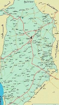
Location and Area:
The Golan (Quneitra governorate) is situated in the south - western angle of the Syrian Arab Republic. It had natural, clear and distinguished borders. In the north, the high peaks of Mount Hermon (Jabal al Sheikh) draw the line of the Syro-Lebanese borders. Mt. Hermon is a high chain of mountains with several peaks, the highest of which is2814 m above sea level. In the west, the Syrian African rift forms the natural borders with Palestine, and the Jordan River
"al Sharia" forms these borders until it runs down to reach the level of -212 m below sea level.
In the south the Yarmouk River draws the borders with Jordan until it reaches a point of 125 m above sea level in "al Hamma". In the east the "Raggad" valley delineates the administrative borders with the governorates of Daraa and Damascus D.C.(Reef Dimashq) inside the Syrian Arab Republic.
The Golan is 64 km long, starting from the extreme north to go down to the deep south. It is 25 km wide in its widest area. So, we can say that the Golan is a meeting point among three Arab countries: Lebanon, Palestine and Jordan.
The Golan is 1860 square km .In 1967 Israel occupied 1250 Square km of the Golan including the buffer zones that separated the Syrian and the Israeli armies.
Administrative divisions and population:
The Golan started to be recognized as a seperate administrative unit in August 1964 after the Establishment of "al Quneitra Governorate from joining two administrative units:
1-Al Quneitra District(then part of Damascus) with other villages: Shita, Hadar, Tranjeh and Jubbata al Khashab. The region was again realigned to include four sub- units: al Quneitra proper, Masaada, al Khushnia and Khan Arnaba .
2-Fiq District: Fiq was part of Daraa governorate. It was realigned to include two administrative sub - units: Fiq proper and al Bteiha with its center, al Mihjar village, north east of Lake Tiberia.
Before the Israeli aggression of June 5th 1967, the population of Quneitra were about 153000 people with an average density of /83/people/square km, which means that Golan was densely populated compared with other Syrian governorates. Now the total population of the governorate is 500 000 people (including those displaced by Israeli Occupation). Part of them(23000)are still living in Israeli occupied areas ,another part(85 0000 live in the villages which were liberated ,including Quneitra, on June 26th.1974. The majority of the population (plus 300 000)live in unusually severe conditions in interim groupings mostly located in the governorates of Damascus, ,Damascus D.C. and Daraa. Those are the displaced people expelled by the Israeli forces after the aggression of 1967.They are waiting the day when they can return to their homes, fields and lands.They are scattered in more than 270 towns, villages and farms in the occupied part of the Golan.